Aggel
As for the names, we emphasize right away: “gel” in the Azerbaijani dialect of the Turkic language means “lake”. In the list of “Lakes of Azerbaijan” Aggel (“White”) stands first. Only because of the size. Its area is 2,800 hectares. But in depth, on the contrary, it is among the four outsiders (pits are only up to 3.5 meters).
The natural reservoir is located on the Mugan plain – in the southeastern environs of Agjabedi (Malskaya steppe). On the one hand, it closes with wetlands of 500 hectares in size (and only for this reason surpasses Sarys in size). It is difficult to call the Pribolotny pool a resort, since it is densely overgrown with rdest, cattails and other reeds. Rather, he is a fisherman.
But they won’t let you cast a fishing rod either. After all, we are talking about a nature reserve. The rarest flora and fauna has been found among the water surface (it is listed in the Red Book of the country). If you want to see her, move along the special designators.
Sarysu
The Azerbaijani lake named in the title is the second largest water giant by volume. It occupies almost 66 square kilometers of the Malskaya steppe, being stretched by 12 kilometers (the maximum width is more than 2 kilometers). The water mirror is very shallow.
Sarysu feeds on muddy groundwater – that’s why it got the name “yellow river”. Its resource is also replenished by rains. The outflow to Kura is controlled by the Muradkhanli hydroelectric complex (a huge reservoir between Sarysu and Aggel). The object is separated from the nature reserve described above by no more than 15 kilometers. Your goal lies to the east of it. And on the way there will be a recreation area with a huge pond and a restaurant of national cuisine “Muradkhanli”.
Administratively, it is the border of Imishli and Sabirabad districts. The facility is accessible directly from Agjabedi via the R-18 and R11 highways.
Hajikabul
Some lakes of Azerbaijan are two–chamber. Just such is Hajikabul (“Sacred Meeting”). Its northern bowl belongs to the town with the same name, and the southern one is already a suburb of the historically significant metropolis of Shirvan. The parameter of the tract is 1,668 hectares (the total length of the chambers is 13 km, the maximum width is 1.8 km). The distance to the bottom is already more decent – almost everywhere 5 meters.
Not the entire perimeter is overgrown with reeds. There are open spaces – meadows from which you can dive into well-warmed water in summer or go fishing. Since the mentioned point is located inside the agglomeration, it is surrounded on all sides by various services – cafes, restaurants, hotels, gas stations, supermarkets and parking lots. This is especially true of Shirvan. The Russians have a popular eco-hotel “Fazenda” (rental of summer houses, barbecues, manicured lawns). The gap between the two lake chambers is an equipped embankment.
Of the natural attractions, the “bald” Mount Haram is interesting – an excellent viewing platform. It is also a historical monument, as cyclopean piles of stones were found on it. Some of them are decorated with ancient petroglyphs.
The place cannot be lost – just move to Shirvan! It remains to add that once this water mirror was formed due to the rapid flooding of the Kura.
Batabat
Idyllic-looking lakes of Azerbaijan are also present in the historical province of Nakhichevan. It is closely adjacent to Armenia. Even the Armenian toponym itself is “The Place of the First Landing”. It is believed that this ancient land, lying at 1,700 meters, is the initial location where Noah and his “creatures in pairs” came after Ararat. The lake indicated in the title played a significant role in the landing.
It lies in the Shakhbuzsky district of the “disputed” region and is included in the Shakhbuzsky reserve. The dimensions are 400 by 200 meters. The tiny bowl was formed by avalanches and landslides. In those “Old Testament” times. And in the center of the crystal clear fresh basin floats an island composed of peat.
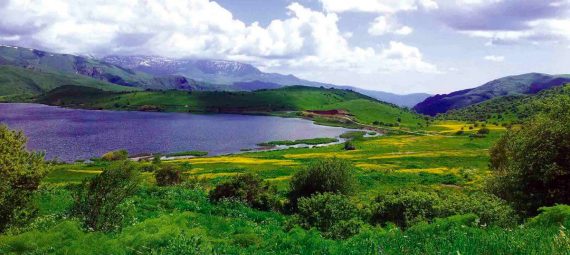
“Bata Bad” means “a place for love” in Persian. It is really very beautiful here – gentle slopes with steppe vegetation, a small patch of subtropical woodlands and a convenient entry into the water. In the background – serious hills with snow-capped peaks. The area is “born” for romance. The grass is an unusually bright green color. There is a neat pedestrian path almost around the entire perimeter. Colorful elegant gazebos are everywhere.
A straight highway leads here from Shahbuz. And only 62 kilometers to go to the “capital” of the named region. Ganlygel and Sarvantygel are also popular among tourists in the mentioned area. But they are quite “microscopic”. To find them, you will have to ask the locals.
Boyuk Alagel
The presented lake of Azerbaijan is a “ruin” of an older hydrological formation. It is stationed on another “disputed” land – on the Karabakh plateau (the most elevated relative to the others). At an altitude of 2,729 meters above sea level. The space of the water mirror is 5 square kilometers (2 by 1.5 kilometers). It has a complex coastal contour. The fixed distance to the bottom is 9 meters. It is considered to be the largest lake of glacial origin here.
“Kara Bah” (Karabag) from Turkic and Persian means “Black Garden” (literally Wild Garden). And “Boyuk Alagel” – “A Large Multicolored Lake”. The phrase itself makes us imagine lush vegetation on the water edges. And of different varieties. The bowl is “nominated” for the title of “the greenest”. It is necessary to add that the water in it is also fresh and always icy.
Location – the northern buffer zone of the state reserve “Jermuk” (here goes the veshka). Travel – from the settlement of Kelbajar.
Kichik Alagel
Recreation on the lake in Azerbaijan can be continued by rising to a level higher than just described. Only 10 meters. Go further along the bridge. That is, a Small Multicolored one lies already at the next mark – near the borders of the same national reservation.
However, the vegetation here is not so much – something like a mountain steppe. And the wind blows. The entrance to the water is very gentle – convenient. The size of the pool justifies the name – only 1,200 square meters. The configuration of the water edge resembles a clover leaf in shape. The depth is 4 meters. The coastal surface is a large pebble, gently turning into different slopes of the surrounding melkosopochnik. Stones often come across at the very edge (you need to swim with caution).
Serious Karabakh peaks are on the horizon. Armenians still call the lake region of Karabakh “Artsakh” – “Dense Forest”. Although today it is no longer possible to see the trees at the level of the described lake…
Garagel
One lake in Azerbaijan (also in Karabakh) as a tourist “business card” is ready to boast of a very “tundra” location. Since it is located at the level of 2,961 meters. Untrained people are already starting oxygen starvation here.
The “black” has a maximum diameter of about 600 m, its small diameter is 300 meters. The maximum distance to the bottom is 10 meters. Bland. Glacial. The village of Minkend is located closest to it. The highway to the city of Lachin leads here.
Geigel
Ganja is another picturesque area in Azerbaijan. Geigel Lake (“Heavenly”) is located just 25 km southwest of the main city of the region, which has the same name as it (as well as magnificent architecture and dozens of historical monuments). But fast forward to Geigel.
Next to the water body is its namesake–the town. And this whole location is at an altitude of 1,556 meters (the western slope of the Murovdag ridge, the valley of the Agsu river). It was formed due to the earthquake of 1139. Glacial. It also feeds on atmospheric precipitation. The dimensions of the reservoir are 600 by 125 meters. But the depth is 30 meters. Scattered nearby are insignificant “puddles” in terms of parameters.
We are talking about another national park. This truly dense reservation has long been the center of attraction for tourists from all over the world, since the riviera is not inferior to Boyuk Alagel in terms of the number of mixed types of lush greenery and wildflowers. The edge is coarse-stoned. An eco-hotel and a restaurant have been built on one of the shores. And the rest of the perimeter is well equipped with infrastructure for a comfortable promenade and photographing the same wooded Kopaz Mountain. Here you can easily spot hoofed animals in the distance. There are swans in the water.
Maralgel
This lake in Azerbaijan, judging by its name, is named after deer. Like Geigel (Gokgel) Maralgel is located in the same area (1600 meters south of the first one). So preliminary city tours of Ganja, where the principality of the same name was located, are inevitable for you in this case.
Outside the city, you will have to cross an impressive stretch of steppe, moving along an equipped road along the Agsu River (it just flows out of the “Maral”). And here it is – the Murovdag ridge. Having risen to a height of 1,699 meters (inside the forbidden forest of the same name), you will find yourself on the coast, sheltered by a broad-leaved forest. But above this narrow strip there are already loaches and outliers on one of the “ridge” sections of the handsome Murovdag. The surface is strongly stony, but sand is also visible between the boulders. There are even points that are generally cleared of stones. In some places there is no grove – only fragments of rocks and large pebbles. The slope towards the bottom goes at a sharp angle (depth of 60 meters!). The water is clean. The cobblestones on the bottom and small fish covered with colorful silt are clearly visible. Only in July there is really a short time to wallow. The rest of the season is dangerous – because of the low water temperature.
The reservoir is 700 by 500 meters, of a clear shape. There are many small rocky ledges, from where one or another half of the lake will fall into the panoramic frame. In some places, the roots of trees or their crowns descend directly into the water. There’s some mud somewhere. The bowl was formed as a result of the same ancient earthquake. By the way, there are so many storks here that some do not have enough lake trees. They build nests right at the ends of roadside poles of power lines. A sight worthy of your photo. Note that on these bright shores, many great lines came to the poet Nizami’s head.
Masazyrgel
But this Azerbaijani lake has a completely different property. “Pink” is really such a color. It is highly mineralized, and salted water, as you know, attracts algae that secrete a characteristic pigment. The shade from orange to red is given by the sulfates themselves.
This “chloride-sulfate” recreation was formed not far from Baku, in the Garadag area (“Black wooded Mountains” at the eastern end of the Greater Caucasus – the Absheron Peninsula). From the capital of the state, a direct road E-119 (“Georgian”) is laid here, passing through 8 more similar reservoirs.
Despite the meaning of the designated toponym, the object is found at a decent distance from the nearest mountain forest. It’s a wasteland. The space occupied by the pink rapa is 10 square kilometers. The shores are flat, the depth is insignificant. Since 2010, salt has been mined here on an industrial scale. The resource reserve is estimated at 1,735,000,000 tons. Slides of salt deposits stick out like porcini mushrooms over the pink surface of the described water bowl. The nearest high–class hotel is Baku Rest (bus stop).
Boyuk Shor
“Big Salt” is exactly how the above Turkic hydronym is translated. Indeed, the liquid brine occupied more than 16 square kilometers. The depth is 2 meters. The maximum width is the same number of kilometers. This bowl is a relic. That is, it could be seen in exactly the same condition by the most ancient “Bakinians”. Another “chloride-sulfide” vacation on the lake in Azerbaijan will be remembered by the newcomer with a new brand – a bridge. He is now crossing the salt surface. And in general, the center of Baku (three of its inner districts converge here). People breathe salt for free, and therefore they are healthy. It’s hard to even say which will impress you more – the lake or its surroundings…
Boyuk Shor is located just north of the ancient sights, but is closely adjacent to the wonders of the 21st century: the main pride of the modern Baku agglomeration. Part of the residential sectors goes directly to the embankment, the hippodrome, the Heydar Mosque, the Azadlig Avenue and Sofaz Tower are visible from afar. The most beautiful part here is Boyukshorsky Boulevard at the southeastern end (there is a city bus stop of the same name). Olympic Stadium, bridge crossing, landscape park, fountains, benches, elegant sidewalks with lanterns. Among all this, there are 3 interchanges of large autobahns.
Jandargel
A vacation on the lake in Azerbaijan can take you to the border with sunny Georgia. Namely, to the border with the south-eastern environs of the fabulous Rustavi (the far half of the lake already belongs to them).
Jandar (in Georgian, “Jandari”) lies on a section of the low-lying left bank of the Kura, 5 kilometers from the river bank overgrown with subtropical massifs. And the lake surface itself is embraced on three sides by low mountains covered with semi-desert vegetation. There is no longer a continuous floodplain forest here – a juicy meadow and a tangled tall shrub that comes with cattails and reeds directly into the water. There are several deciduous trees standing alone.
The largest diameter does not reach 3 kilometers. The area is about 5 sq. km. The depth is insignificant. In fact, it is a liquid reservoir used for irrigation purposes. All the banks are flat. Pebbly-earthen. The place is pretty polluted by picnic lovers.
The nearest station is Boyuk Kasik. The population of the nearest farms is half Georgians, half Azerbaijanis. There is a large Armenian Diaspora in Gardabani itself (the nearest city). And in the nearest mountains there is a village with Assyrians.